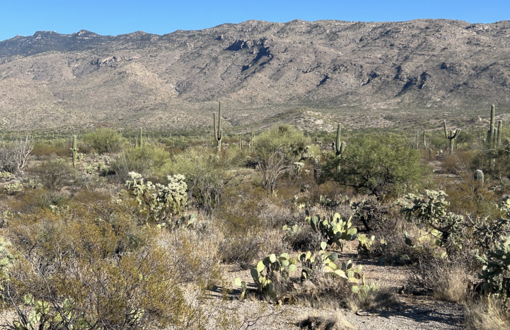
Glacier National Park, Banff in May Part 1

Running the Whitefish Marathon was the original plan six months ago when I booked my travel to northwest Montana. Most of my plans change dramatically especially in 2022 and 2023, and now into 2024. This plan changed, too. I am still on the hunt to run a marathon in every US state; I have finished 12 states – which is why this plan became a plan. 

My training for a marathon starts out pretty well, following Training Peaks plan for several weeks. Then, I hit Week 8 and I miss days; I miss a key 16 mile run on the weekend. This is what happened with the Little Rock Marathon and the Whitefish Marathon. 

What tends to happen is I drop down to the half marathon and start planning all the things I will see before and after the race. When you run a marathon, you usually don’t have the energy to travel and go see things. When I dropped to the half at Whitefish, my plan for Montana turned into travel to Banff, Canada and more. This is part 1. I’ll have to come back again, some day to complete a Montana marathon.

On May 15, Wednesday I flew into Missoula and drove to Kalispell. I checked into my hotel and drove east to West Glacier to spent the rest of the first travel day in Glacier National Park. May is such a perfect time to visit; there were no crowds and  great temperatures; 67 degrees. I stopped at Lake McDonald Lodge and walked around the shore.

I promised myself I would stop at everything and read all the signs; and not rush through everything (which is my natural tendency because I want to see everything). I drive toward the Going to the Sun Road. I know it’s closed but I want to see if I can walk a few miles up. Instead, I walk the trails around Avalanche Lake trailhead and hike the Trail of the Cedars loop.

The trees and trail are gorgeous. I start to worry about bears but then see the turquoise water flowing down from Avalanche Lake and my worry dissipates. I keep walking and exploring. I read all the signs about the trees. I wish I had more time to hike to Avalanche Lake. I know I hiked this trail last time I was here but the sun is starting to set and I get nervous again. Next time, I say to myself, next time. 

I drive back to Kalispell and wake up at 5am to drive to Banff. I cross the border and I’m driving through the freaking Canadian Rockies! They are just stunning and I’m on the Trans-Canada highway just thrilled to be here. The mountains in the distance are huge. The rivers are turquoise. I’m here with the biggest smile on my face.

I’m so extremely happy because I didn’t get to come to Banff 36 years ago on my first trip out west. I came west from New Hampshire in 1988 on a Youth Hostel trip. Our group traveled and hiked, and stayed in hostels in all the western National Parks. We went to Rocky Mountain National Park, Grand Teton National Park, Yellowstone National Park and Glacier National Park. We were supposed to go to Banff, but couldn’t since the trip leader forgot her Australian passport. We couldn’t drive into Canada so we staying those extra days in the hostel in Polebridge, later hiking Numa Ridge near Bowman Lake, and playing in the North Fork of the Flathead River. 

I drive into Banff and it’s not what I expect; it’s better. The downtown is small with huge mountains surrounding the town.

Light rain falls as I head toward the Banff Gondola. I really should hike to the top of Sulphur Mountain but I want to have enough time to do everything. I’m here for one night and want to explore.  The gondola was a great way to get to the top and see the  view that I’d been watching for months from their webcam. I walk the boardwalk to explore the top and see hikers coming up the trail.

The top of the mountain has an interpretative center with videos and photos to learn about the area. I read mostly everything. 

I walk around town, eat and check into my hotel, The Moose. I take a sauna and swim in the rooftop pool. It reminds me of living in Steamboat Springs where I started training to be a triathlete. I would swim in the Old Town Hot Springs thermal heated pool and sit in the sauna after. This is what I needed to end my day in Banff. An absolutely perfect day. As I start to leave the rooftop area, it starts to snow.  I walk around town and find a place to eat – Sushi!

The next morning it’s time to run – I need some cardio. As I leave the hotel it is snowing with about an inch on the ground. It is 2 miles to the top of Tunnel Mountain with 900 feet of elevation gain.

I’m so happy to be running in the snow and there is no one in sight; and there are no views. I read the trail description and know that there is wildlife here and I should be on guard. And like always, about a mile in I get nervous and think of turning back. But then ahead of me, out of the snow swirling a woman hikes toward me, coming down from the top. If she can do it, I can do it. I carry on. View my video of my run/hike here.

I get back to the hotel, shower, pack and head to breakfast. I love Canada so much. Steaming coffee, and just a perfect presentation.

And start the beautiful drive back to Montana through a snow storm.

West to Little Rock

Go see the world, she said.

So I did.

Most of my racing and travel posts starts with a trip’s intent. If you are a frequent reader, you know that changes a lot especially right before the trip start.  

I signed up for the Little Rock Marathon six months ago. I signed up because I wanted to see Little Rock. I wanted to see the capital area, the Arkansas River and the Bill Clinton Presidential Library. I also wanted to drive into Oklahoma via the Trail of Tears byway. 

But first, a six-hour drive to Memphis where I stopped on the first night. I spent a few hours in the National Civil Rights Museum, 450 Mulberry Street. When you walk up to the museum, you see the Lorraine Motel as it was in 1968. In the museum they exhibit the history of the American Civil Rights Movement. Such well organized displays and thought provoking images. One exhibit shows what MLK’s hotel room looked like that he stayed in before he was shot. It felt strange to be walking around so much history that I’ve read about and watched on TV. I’m still processing what I saw and learned.

I walked through downtown, exploring and eating at a Mexican restaurant, reading area brochures and learning about Memphis. 

The next day, early start to Little Rock and packet pickup. I decided that I will run the half marathon instead of the full. I feel like dropping down in races is so 2023-of-me. However, the pattern continues in 2024. Please stand by. My race approach is evolving. But I digress…

I drove over the Arkansas River. The last time I saw this river was in Colorado last year when we visited the Royal Gorge. And now I see it as it joins the Mississippi in Arkansas. The Arkansas River is the second-longest tributary in the Mississippi-Missouri river system, originating near Leadville, Colorado – my favorite racecation destination. 

The entire registration was held in the Little Rock Convention Center. Using indoor. bathrooms is such a luxury with a big race like this. The dinosaur-themed race was festive with so many runners dressing silly. I was looking forward to race day.

After getting my bib, I drove to Little Rock Central High School. I walk around the grounds and read about the 1957 event and learn more about the Little Rock Nine.

I have enough time to drive to Fort Smith National Historic Site which is two hours from Little Rock. I walked through the historic fort and park, read the signs to learn about the fort’s history. I walked along the Arkansas River, which was heading towards Little Rock and the Mississippi.

I drove into Oklahoma, ate lunch and started back to Little Rock. 

I get back to the hotel, which is a half mile from the race start. Sometimes pre-trip planning doesn’t work out, but this time, the location works out to my advantage. And, it just so happens the Clinton Library is a short walk down the street. I walk around the campus since I missed open hours. There is some sort of fundraiser or event happening as I walk around; people are dressed up and entering the museum. 

Sunday: Race Day. I wake up at 4:30am for a 6am start. Originally the race was planned to start at 8am but due to unseasonable warm weather and humidity organized changed it to an early start. 

It’s 4:35 am and I really didn’t want to run. I wanted to sleep in and drive home. I get this way traveling sometimes; I just want to be home with my dogs. But then I force myself to remember this is a planned adventure. I want to do this. I want to run Little Rock.

Marathons (and shorter races) really allow me to see a place. I hemmed and hawed for a good 30 minutes and ultimately got up, put on my race clothes (read: big girl pants) and walked to the start. 

I was so happy to be at this start line. I always forget this.

The race start wasn’t what I expected, but almost nothing is anymore. 

There were thousands in the corral. Marathon and half marathoners all together in letter-labled areas. I was in E. 

I usually talk to people and get pumped up to start but today, I didn’t talk to anyone. I sat and stretched and took a few pictures. 

It took about five minutes to get to the start line and I just ran my pace. I no longer have a race pace – I have a pace I always run. My comfortable pace is between 10 and 11 minute miles. 

We ran through downtown and around a few residential areas and made our way back out to Central High School. The school’s marching band played for us as we ran by. Then suddenly I am at 13 miles and we are back to the start. The temperature was perfect: 55 and misting. No Sun! 

I’m so glad I finished this race. 

I walked back to the hotel and showered. I was sore! But I was also ready to head home. 

I drove home across the Arkansas River and the Mississippi River. I drove past Memphis and Nashville. As dark descended, and 8 hours had passed I was at Exit 407 and home was 30 minutes away. 

As of today, I have two states left to visit: Michigan and North Dakota. Let the trip planning begin.

How to fuel before a road trip: Flapjacks at Exit 407 Sevierville.

Go see the world.

Day Three – Petrified Forest National Park and Saguaro NP

We woke up at 5am knowing that we had to get to Tucson before Saguaro NP closed at 4pm. Total mileage from Cortez, CO to Tucson, AZ: 538 miles. 

This time when we drove past Petrified Forest National Park it was open so we went in. 

I thought this was a small park off the side of the highway, but it ended up being a spectacular one hour drive south through an amazing landscape. 

Petrified Forest National Park was more that I ever expected. The views from driving through were beautiful, like a painting.

The Petroglyphs were so interesting to see and learn about the history of who did this to the rocks.

We got out and read the signs and learned about everything in the park. We stopped and walked the Blue Mesa Trail. We learned about how the trees became petrified and the climate change that caused them to be petrified. 

The biggest lesson learned on this trip is I want to know more about where I’m traveling before arriving. I would’ve liked to hike more trails in Petrified Forest. But also, it is sometimes hard to image a place and read about it before going there. Now, I’m reading more about this area and it makes more sense after being there. 

After exiting from the South Entrance it was onward to Tucson. The scenery is canyon and rock and desert. So many prickly pear. The cliffs made of sandstone dotted the landscape. We are in Apache country now. We drove through Tonto National Forest at an elevation of 5,840. 

Some of the signs I saw:

Truck Crossing
Free Wifi Wendy’s
Speedway – Fresh Coffee
Elevation 4,983
8% grade
Winkelman City Limits
Entering Pinal County
Aravaipa Creek
Biosphere 2
Entering Pima County

Saguaro National Park was exactly how I left it in 2015 – Gorgeous. We drove the road that I had run in a race and biked several times. The paved, hilly road that passed hundreds of Saguaros. 

Then we drove into Tucson met Kassandra for dinner and then back to Phoenix. The last day was a lot of driving in a beautiful landscape. I miss Tucson and I would love to live here again some day.

Route 66, Four Corners, Mesa Verde

We left Flagstaff at 5am. Every morning on this trips was an early morning, packed with things to see. We purposely picked this route so we could see Winslow, Arizona and the famous location of the song, Take It Easy. We got there before the sun rose and there was no one around. 

It was so worth the trip of the highway to see. We played Take it Easy as we arrived. We studied the background of why Jackson Browne wrote about this location. Here’s what I found out:

As legend has it, Jackson Browne was driving to Sedona on Route 66 when his car broke down in the middle of Winslow. Winslow had some acclaim in the 50s with a celebrated hotel, the historic La Posada hotel. Then , in the 60s the town almost disappeared after I-40 was built and by-passed the town.

We took some photos and then it was on to the Petrified Forest National Park. We got there too early, it wasn’t opened yet. So we took a photo. I didn’t want to wait because I really wanted to spend as much time at Mesa Verde. I had been reading so much about the park and the cliff dwellings, I didn’t want to waste any time. [Note, we ended up spending a lot of time in Petrified Forest the next day, on the way to Tucson.]

We continued on toward the Four Corners Monument, Navajo Tribal Park. Monument on Route 40.

We drove past Gallup and Shiprock, and admired the Painted Desert. It was so beautiful watching the sunrise in the middle of the desert. 

We turned off the highway, for the Four Corners Monument not knowing what to expect. In the middle of nowhere was this park and buildings. We paid our admission and entered. There were vendors all around the middle of the park selling native american art and jewelry. I wanted to remember this place since it was magical with the flag and the history and wind, so I bought a ring from a native american woman. We took a bunch of photos and then headed to the hike. 

We hiked down the trail stepping in all four states: Arizona, New Mexico, Colorado and Utah. It is a rugged landscape and today the blue sky was accented with puffy, white clouds. October is the best time to go here. Very few people were here so there weren’t any lines, and it was cold-ish. 

Now it was onward to Cortez, where we would stay the night, and Mesa Verde. The drive was spectacular and clouds threatened the entire afternoon. We could see oncoming dark clouds most of the time and got rained on a bit. But there were not many people in the park which made it very nice. There was a fire here, too, in 2002. You can still see fire scars driving to the mesa.

Mesa Verde was magical. It was everything I expected and more. It has a vibe, something in the air that made me feel the history, the people who lived here. As we started the drive up to the mesa I was just awaiting after every turn something beautiful but the coolest part was when I got out of the car, walked the trail, and just around the first curve, I saw it – the cliff dwellings under the overhanging cliffs. Cliff Palace.

There is nothing like it in the world. I just stared and couldn’t take my eyes off it. I walked closer for a different perspective. It was spectacular, I felt the sacredness of this place. We stopped at Spruce Tree House, Cliff Palace and Balcony House. 

Guided tours of the cliff dwellings ended a few days before we arrived so we could only look from afar. Next time, and there will be another trip here, I will do a tour and get close. 

I wanted to come here and just be in the park, experience being there. I wanted to take in the landscape and watch the sky. This is exactly what I did. We brought our lunch and sat on a bench and just watched. On the drive back down we stopped at the Fire Lookout and took in the amazing views.

I cannot wait to come back here.

We stayed the night in Cortez and at first light, headed south to Tucson and Saguaro National Park.

Grand Canyon and Flagstaff in October

My original plan was to run the Javelina 100K. I signed up six months prior to the start date. 

Training didn’t go as planned. Blah blah blah. 

In September I decided that I would instead take a tour of National Parks and visit the legendary 4 Corners

My travel partner was Mark, who initially offered to crew my 100K race, then decided that touring the National Parks was a good vacation idea, too. 

I planned to see my friend Mary on Friday night to wish her well on the 100K but my plane was late and the lines for the car rental didn’t get me out of the airport until 11pm. [Note: Mary loved the race and wants to do it again, so I have a second chance to do it at some point.]

Saturday morning Mark and I left for the Grand Canyon at 5am. We drove past Sedona and Flagstaff wanting to spend as much time at Grand Canyon and Bright Angel trail as possible. Our only stop was for a late breakfast in Tusayan. I had the most amazing Huevos Ranchos. 

We got to the park and headed straight to Bright Angel. I wanted to go down at least 3 miles. I loved seeing the trail in the distance; I just wanted to hike to the river. We occasionally caught glimpses of the Colorado River.

The trail was steep in places but also leveled out for a nice break. It was nice to just take a leisurely hike into the canyon.

Usually my hiking plans take on a life of their own and I go go go. But this time it was a slow pace, checking to make sure Mark was good. He’s more of a road runner and doesn’t really hike – but is in great shape. He did well. 

We ended up hiking 2.5 miles with 722 feet of elevation gain. 

After visiting the shops on the South Rim we took the shuttle west and walked along the Rim Trail. We were able to see the Colorado River and stopped at the Powell Monument honoring Major John Wesley Powell who was among the  first to ‘run’ the Colorado River in Grand Canyon. 

I’ve read Stegner’s book about Powell, and have read so many historical stories about Powell. He was the person who warned the government about the west’s aridity that wouldn’t be able to sustain agriculture. He was also a scientist. He also advocated for removal of Indigenous, which no longer makes him a hero, in my view. 

It was a cold day in October to visit the park – so much better than sweating, which was the case the last time I visited the Grand Canyon in 2015. 

Mark and I drove back to Flagstaff past Humphreys Peak in the Coconino National Forest where we saw the devastation from the fires in 2022. In the picture below you can see the blackened tree trunks.

We had dinner in town and stayed the night in a hotel. It was a long day seeing northern Arizona. I can’t wait to go back. Mark and I have a plan to come back this coming October for a Rim to Rim hike.

Next up Route 66, 4 Corners and Mesa Verde.